Canadian Shield Field Trip 2001:


This report is devoted to present the experiences of the Student Members from the Eötvös Loránd University SEG Student Chapter, gained at a 2-week field trip in Ontario, Canada, in August-September 2001. The group comprised 7 third-year students and was accompanied by Dr. Feri Molnár, associate professor in mineralogy and metallogeny, and Fellow of the Society, as well as by Krisztián Szentpéteri and Zsolt Hefner, Ph.D. and M.Sc. students in metallogeny, respectively.

The speciality of the trip was yielded by the circumstance that it somewhat preceded the official approval of our student chapter as a Student Chapter. We feel, however, that both the organization of and the enthusiasm on this trip had taken place in the spirit of the forthcoming, i.e. official status of our Student Chapter.

The principal goal of this field trip was to get in acquaintance with (1) sulphide and oxide deposits genetically linked to mafic magmatism, (2) gold deposits related to medium grade metamorphism, and last but not least, (3) fresh Archaean and Proterozoic rocks as such, including not only medium to high-grade metamorphites but such exciting, and in the territory of Hungary unknown, rock varieties as carbonatites, jacupirangites, glacial diamictites and tillites. These impressions were augmented by an excellent weather. Besides numerous stops, our circuit involved visits to five mine sites, as well as creating a geological profile in the vicinity of Victoria Mine, Sudbury.

The exhaustion due to the long flight was counterbalanced by an extremely good view at Southern Greenland, with most of its glacial features - icebergs, fjords, glaciers, nunataks etc. - being well visible (Pic. 1).


Picture 1.: Greenland from above, just over the edge of the highland.

On our arrival in Ottawa, we were friendly welcome by Professor David Watkinson from the Carleton University, who guided us for the bulk of our itinerary. We allowed ourselves a day rest and adaptation to time shift before hitting the highway and heading for the outcrops of the Grenville Province. Many thanks go to Uncle Paul who provided us with his wooden house for free, located right at the Calabogie Lake, and for that he was often there with us, for friendly chats.

The first day at the Carleton University, Ottawa Prof. Richard Taylor presented a lecture to us about the role of fluids during the evolution of granitic melts. We were then shown around in different labs, including a mass spectrometer for Rb-Sr and Sm-Nd measurements.

At our first stop, Arnprior, we studied nicely folded graphite-bearing marbles and cross-cutting mafic dykes, apparently metamorphosed in greenschist facies. This unit is thrusted upon a non-metamorphosed, Lower Ordovician carbonate sequence. This signature of intensive brittle tectonics was explained by the incipient development and subsequent failure of a Lower Paleozoic rift system, its product collectively termed as Ottawa Valley Graben System. It is assumed that the Cretaceous carbonatite intrusions near Montreal are structurally related to the former. From the economic point of view, the increased heat flow and outflow potential, which are typical of a graben structure, give rise to migration of ore-forming fluids, along with the genesis and emplacement of a variety of alkaline rocks.

Near Bancroft we took a look on an excessively spectacular nepheline-albite-microcline pegmatite, with an alteration paragenesis comprising muscovite, various zeolites, hematite, sodalite. The unusual peraluminous character of this assemablage still raises some questions. At the border of this pegmatitic intrusion a skarn assemblage was found, comprising the common phases diposide and grossularite but also such rarities as talc and humite.

Then we drove from Calaboogie to Timmins. Again, this time at the Indian road crossing, we experienced how useful is that - chiefly theoretic - knowledge picked up during innumerable undergraduate courses is complemented on the field. The road cut exposes several kilometres of a wide variety of migmatites, still pertaining to the Grenville Province. They exhibit a nicely alternating sequence of bands of leucosome and melanosome. Occasionally occurring porphyroblastic texture, i.e. large feldspar phenocrysts in a fine-grained matrix, points to metasomatic processes affecting the texture. Patches of sulphides found at the same place supported our view. Ductile deformation is common as many folds, mini-intrusions and ptygmatitic structures were observed. What is more, we found a basaltic dyke of about 12 m thickness penetrating the sequence as a whole.

The second part of our journey took us to a couple of mine sites near Timmins, Canada's largest city by area. These tours were guided by Mr Brian Atkinson, resident geologist, Ministry of Northern Development and Mines, Ontario. There are about 60 operating mines in the western part of the Abitibi Subprovince of the Superior Province, with a total Au production of about 500,000 oz/yr. The Tisdale region, situated S of the Destor-Porcupine Fault, hosts a substantial fraction of the gold deposits. Besides, base metals are also economically important and thus exploited. The Genex mine, for instance, was located upon N-S- trending formations and operated until the late 1960s. A set of E-W- striking transform faults cut the stratigraphy, hence gave rise to mineralization along them. The principal host lithologies comprise mainly mafic and, subordinately, felsic breccias. Vesicular rhyolites and associated pillow basalts suggest bimodal volcanism in a back-arc setting.


Picture 2.: Nicely conserved Arcaean pillow basalts, Abitibi Subprovince of the Superior Province.

During exploration, 39 boreholes were drilled most of which traversed mafics. Mafics as host rocks are an interesting exception here because at the world class VMS deposit in Kidd Creek, felsic rocks accommodate the mineralization. Since the pristine preservation of Archaean hyaloclastite was possible, an a priori path for ore-forming fluids was produced. 
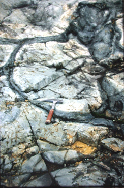
A sulphide crust found around a number of pillows accords with this idea. At the Canadian Jamieson Mine, located on the same sequence, we encountered exclusively felsics. These spherulitic rhyolites are enriched in potassium as it had substituted for sodium, displaying a sericitic alteration due to submarine hydrothermal activity. This alteration may reach the stage of kaolinization at different places, and represents, along with the fairly common occurrence of some quartz-tourmaline-ankerite veins in adjoining granophyres, a good indicator of pervading fluids. 
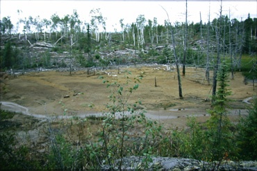
Another nice example of a VMS deposit was seen at the Kam-Kotia mine. We got here a true impression what a "massive sulphide" body looks like as we studied swarms of pyrite+chalcopyrite dykes, neither of them less than about 1 m in diameter. On the other hand, the mine, which was operated until 1972, has been labelled the "the worst environmental disaster" in Ontario.


Picture 3.: The mine site left behind.


It was opened in September 1943 as the Federal government wanted copper for its effort during World War II to defeat Germany. It asked the Hollinger Gold Mine to mine the copper. At the time, there were no restrictions or concerns about pollution. The mine produced 5.5 million pounds of copper concentrate at a loss of $140,223. Now, an official estimate puts the cleanup costs, a five-phase program of which three has already been completed, at $28,000,000. We were unhappy to see that the contamination that leaves the site, including its acid swamp, is blood red. More importantly, there are 125 cottage owners and 350 people living at the lake who are presumably bitter about the long delay in addressing the site...

We then moved on to participate the famous Gold Mine Tour in the Hollinger Mine. It was discovered and first exploited by Benny Hollinger in 1909 and soon became the richest gold producer in the western Hemisphere with total gold production of $400 million, when gold was selling for $35 to $40 an ounce! We looked at one of the 250 uniform but comfortable houses where the miners lived in. As mine was in its prime, thousands of employees worked in and around the down to 6500 ft shafts. Until 1967, when the mine was shut down, 1,950,000 oz Au was produced. However, in 1975, when the price of gold raised to 500$ an ounce, the re-opening of the mine was considered yet never implemented. Exploitation in an open-pit was started instead but it was halted soon. We were introduced to the working routine of a hewer by a retired miner. He escorted us down the main drift, pointed out features, demonstrated mining equipment and explained mining operations. A mock explosion and some videos contributed to the experience. On the surface, we tried our luck by panning for gold but... it seemed that we were inevitably experts as the "beginner´s luck" principle apparently dit not work.


Picture 4.: The group posing in the Hollinger Museum mine, Timmins.

The third part of our journey took us to the Hemlo-Marathon area. On half-way to Marathon, near White River, the antiquity of the Cedar Lake Pluton is exposed. It consists of granodiorites and granites, and was dated to be 2687 Ga. Important is, of course, whether magmatic thus ore-forming fluids could have been released or not during crystallization. This may shed light on a possible relationship of the pluton to the Hemlo deposits. This presumption was checked and we found pegmatitic pockets and miarolitic hollows showing a late magmatic fluid enrichment and segregation. We then made the next stop at Hemlo and had a look at the giant mining projects. The site comprises 3 mines, which give 20% and 50% of the total Au production of Canada and Ontario, respectively. It was discovered in 1981 and the production culminated in 1992. Now, with an average annual production of 1 Moz Au the company has more than 80 years of reserves. The gold may concentrate up to 29 ppm and is 7-8 ppm on the average. Its occurrence is restricted to a E-W-trending zone of a couple of tens of metres thickness, 1.3 km depth and 2-3 km length. The zone itself is a contact of an acid volcanic succession and a volcano-sedimentary sequence. The most auriferous zones are found within porous, tuffaceous units. Approaching Marathon, one may enjoy a marvellous view of the Lake Superior.


Picture 5.: The cobble beach of Lake Superior.

Much more famous is this area, however, for the Coldwell Complex. It´s about 1 Ga in age as its formation is a result of the igneous activity along the Mid-Continental Rift. It covers an area of a few hundred square kilometres and is made up chiefly of alkaline gabbroidal rocks, associated with nepheline syenites. Three phases of intrusion can be distinguished, the younger the event, the more acid the bulk chemistry. Country rocks are metasediments of the greenstone belt of the Superior Province. Increased temperature during emplacement of the mafics forced the felsic country rocks to melt locally; subsequent slow cooling resulted in graphic to granophyric texture. An intensive volatile mobilization front at the contact is shown by pronounced biotitization and pegmatite formation. PGE enrichment is common at the contact. At the deeper parts of the intrusion there is a well-developed layering consisting of plagioclase-rich and opaque-rich bands. The plutonic sequence as a whole was associated with a subvolcanic-volcanic edifice. Although this has been eroded by now, indirect evidence for its sometime presence is given by cogenetic xenoliths flopped into the magma chamber, probably due to a catastrophic collapse. Fragments of both massive and vesicular basalts as well as various monzonites were found. At the lakeside, we collected a number of rounded, fresh and exciting cobbles of high-grade metamorphites (and envisioned in advance the horrible overweight fees at the airport. Progressing towards Wawa, near Fire Sand Lake, we studied extremely spectacular pillow basalts, with their pristine structure retained but displaying a nice metamorphic assemblage of epidote+carbonates+quartz+ferroactinolite. The age of these rocks scatter around 2.7 Ga. At the same place, right below a pothole phenomenon, so typical of glaciated regions, we found a vertical carbonatite dyke half a meter or so in width. Texturally, it is akin to common orangebrown dolomites and no igneous silicates were observed. Its formation may be related to the Mid-Continental Rift and directly linked to the Coldwell Complex, as dating on these rocks yielded ages of about 1.08 Ga. In general, such bodies, if large enough, host economically important Nb-Ta and REE mineralization as does, for example, Oka carbonatite near Ottawa. Therafter, we were prepared to bump into a kimberlite pipe right around the next corner.

The fourth part of our journey took us to the remote Cobalt area, followed by a long, grueling driving partly in an unmaintained dirt road between Sultan and Highway 144. On the way, we passed the Arctic/Atlantic watershed, which was, beyond doubt, droll for the visitor from a hilly to mountainous country.


Picture 6.: The Arctic Watershed.

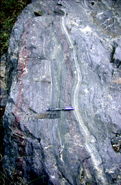
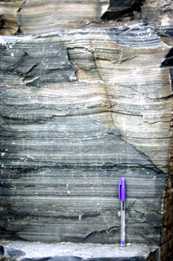
Temagami was the next locality we passed on our way to Cobalt. There, well-exposed Superior-type BIF was observed. The formation consists of a monotonous sequence of repetitive alteration of jasperite and iron-rich bands, all of them ranging 1 to 5 cm in width. It was deposited on the deeper shelf. The iron-rich bands constitute mostly or exclusively of magnetite, however, they may have been originally precipitated as hematite. This type of hematite › magnetite transformation is referred to as musketovitization. In addition, amphiboles (e.g. antophyllite) and chlorite may show up, too. The whole sequence was metamorphosed in upper greenschist to amphibolite facies. Signatures of both brittle and ductile deformation appear, the most spectacular of them being pinch-and-swell structures on a cm-scale.


Picture 7.: Banded Iron Formation, near Temegami.

The Proterozoic tillites, overlying the Archaean basement, are grouped together into the Gowganda Formation and are exposed, for example, in a road bend 4 km south of Cobalt. Hitherto these rocks were known for us only from the textbooks. These are extremely disorganized, mud-supported sediments with a high proportion of lithics of various size and material, being unsorted and chiefly angular. They are interpreted to have been transported by an ice-sheet and "frozen" as the ice vanished due to melting. The tillite is unmetamorphosed, reflecting that there have not been significant orogenic processes in the Laurentian Shield since Early Proterozoic.


Picture 8.: Proterozoic tillite of the Gowganda Formation near Cobalt.


Picture 8.: Proterozoic varvite of the Gowganda Formation near Cobalt.

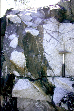
Approaching Cobalt, a dyke of the Nipissing Diabase was observed; picked out from the topography by erosion and striated by glaciation in agreement with its 2.2 Ga age. The ore-forming fluids of the Cobalt mineralization may have been derived from such dykes, however, a different assumption deals merely with the released heat giving rise to a preexistent reactive brine to start circulating and thus mobilizing metals from the counrty rocks. Elements of economic importance are Ni, Co and Ag. Cobalt, as its name already suggests, owes its establishment to the first prospectors to seek for orebodies at the very beginning of the 20th century. Interestingly, the railroad itself was run to this region in order to facilitate the exploitation of pelitic sediments of outstanding quality in the so-called Clay Belt. Meanwhile, Ag-rich dykes were discovered, and before long, a true silver-fever commenced. The mining in the area contributed significantly to the prosperity of N-Ontario until the 1960s when the last mine was shut. The most important phases are native, disseminated Ag, safflorite, cobaltite, breithauptite, bismuthite, arsenopyrite, loellingite. We toured many of the facilities of the abandoned mine, including wooden headframes. Along the well-maintained path, a number of boards provided us with useful information concerning the one-time orebodies, mining equipments as well as the environmental problems left and proposed solutions thereof.

The fifth part of our itinerary comprised numerous outcrops within the Sudbury Igneous Complex (SIC). We joined a group of undergraduate students from the Carleton University, Ottawa, led by Prof. David H. Watkinson, Prof. George Skippen and Zsuzsi Magyarosi. The 1.85 Ga SIC is a 60 km long and 20 km wide elliptical body, situated at the contact of the Archaean Superior and Proterozoic Southern Provinces. Large is the number of works arguing that SIC was formed as a result of a meteorite impact. The jury is still out on whether the timing and formation of the SIC is related to the Penokean orogeny, but it should borne in mind that the impact might have taken place during orogenesis. In this sense, the elliptical shortening of the impact crater could be explained by large-scale orogenic deformation. The SIC consists of three main igneous units: (1) the 100-m-thick sublayer norite, occupying embayment structures at the base of the (2) main mass mafic norite which is sequentially overlain by felsic norite, quartz gabbro and granophyre, a myriad of offset quartz diorite dikes (3) associate the elliptic body of the SIC and are likewise volumetrically small. They group into two main types: radial offsets extending away from the complex, and concentric offsets forming ringlike structures centered on the complex. The total original volume of these rocks is estimated to be 8,000 to 14,000 km3. On the basis of geochemical data, it was assumed that the main mass could be generated by in situ melting of the upper crust. More recently, it was shown that there is a considerable compositional break between the felsic norite and the granophyre which could not be explained any longer by differentiation by a single magma. It is possible therefore, that a mantle contribution is also present, however it may not total about 20% as the ratios of the incompatible elements of the two rock suites in question are markedly similar.


Picture 9.: Sudbury Breccia in the Archaean granitic footwall.

After studying the transition from norite to granophyre in the North Range near the Windy Lake Prov. Park, we drove to the South Range to have a look at the contact sublayer, the most important economic unit of the SIC. The sublayer norite is directly underlain by brecciated rocks of the metamorphic basement, or, Huronian metagranites and metavolcanics. The norite, or more specifically, the quartz norite is easily recognized by the splendid blue luster of the quartz grains in it. As mentioned above, the geometry of the contact often displays marked irregularities, referred to as embayments. These are places where the orebody seems to occur, and the Creighton Mine is located onto one of the largest of such embayments. The brecciation of the basement was produced by the passage of shock waves. Together with the offsets, it contains the 
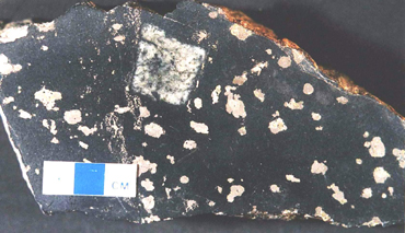
Ni-Cu-PGE mineralization. Pt+Pd concentrates in the sublayer up to 1-2 ppm. The Copper Cliff offset, the most prominent of its kind, is made up of quartz diorite. It hosts a substantial fraction of sulphide mineralization, 
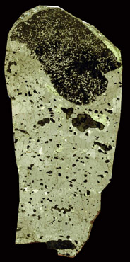
occurring in the form of blebs and heavily disseminated grains.


Picture 10.: Blebby sufide (pyrrhotite-pentlandite-chalcopyrite) in quartz diorite of the Copper Cliff Offset.


Picture 11.: Inclusion bearing massive sulfide of the contact sublayer type deposits, Crean Hill mine. Width of sample is 4 cm.

Their formation is explained by high temperature immiscibility of silicate and sulphide liquids. In such a highly convective system, it was not possible for the sulphides to sink to the bottom and accumulate after segregation in the form of monosulphide solid solution. Therefore, along with the cooling and crystallisation of the silicate phases, and increasing bulk viscosity, the sulphides were forced to remain where they were produced, however, solid-state transitions from MSS to sincere sulphide phases took place uninterruptedly. The sulphide blebs are often rimmed by volatile-rich silicate phases such as micas, epidote and amphiboles. Most important metals in sulphide bonds are Ni, Cu, Fe and PGE even though it is not economically worthwhile to concentrate the Fe from these rocks as there are cheaper places for this purpose. As contrasted by the sublayer, the offsets may have a Pt concentration up to 10-12 ppm, suggesting that there has been either an injection of an extremely differentiated sulphide magma or, more probably, a secondary remobilization has taken place driven by pervasively circulating hydrothermal fluids.

Additional miscellaneous observations around the SIC included fallback breccias near Onaping Falls (Onaping Fm.), interlocking limestones and shales of the Vermilion Mb. of the Onaping Fm., pyrite accumulation horizons in a balck shale unit (Onwatin Fm.), and a greywacke sequence (Chelmsford Fm.) in which the Bouma Ta-c divisions were still well discernable. Sedimentation occurred as a result of erosion of the Penokean orogeny. There are light-coloured spheroidal concretions in the latter sedimentary succession, 20 to 50 cm in diameter. They are believed to have been formed by algae to convert native carbon into carbonatic bond. Furthermore, we observed staurolite-bearing micaschists near Copper Cliff - Clarabell Mill. Retrograde metamorphism caused the staurolites to convert into sericites and apparently preceded the Sudbury event. As a result of serious SO2 emission of the mining industry, a black coating appeared on these otherwise beautiful rocks. Since sericite is more resistant to low pH values caused by acid rain, present-day erosion picked up the individual grains from the rock surface. At the Big Nickel mine site, we observed nicely layered meta-wackes (McKim Fm.), with well-developed chloritoid crystals, representing one step down from staurolite in metamorphic grade. Quartz vein fills, obviously precipitated from an aqueous solution, were also observed here. They displayed marked Riedel planes and tension gashes, indicating unambiguously a sinistral sense of shear deformation. In the Ramsey Lake Road, many examples of the shatter cones were seen, all of the developed in cross-laminated shallow-marine sandstones. Since they spread away, like horsetails do, upwards, it could be estabilished that the section of the sequence was in overturned position. Between Victoria Mine and Vermilion Mine, a garnet-bearing metamorphite crops out. In its matrix, chlorite, biotite, amphibole as well as white mica can be recognized; the garnets theirselves range in diameter from 10 to 100 (!) mm. As the bulk chemistry of the rock is apparently very rich in Al, it is assumed that a hydrothermal activity that affected the protolith resulted in the simplification of the chemical composition of the rock mass and thus relative enrichment in immobile elements such as Al.

We then went on to have an impression how a major boundary between two megatectonic units looks like, i.e. the Huronian Supergroup to the N (up to 2.5 Ga) and the high-grade metamorphites of the Grenville Province to the S (about 1.1 Ga). The tectonic boundary is marked by intense mylonitization and formation of adjoining ?- and ?-clasts in the igneous rocks of the Grenville unit. Walking then into the more-than-1-billion-years-older rocks, one may recognize mafic dyke swarms, which are, unlike Nipissing Diabase, seemingly unaffected by the brecciation (i.e. Sudbury event). They are made up of olivine diabase and pertain to the Matachewan Diabase Fm. Based on this field evidence, the intrusion of the Matachewan dykes postdates the Sudbury event.

500 m E of Wahnapitae, kyanite-bearing garnetiferous micaschists are exposed, with a beautiful synkinematic deformation in the garnets.

We drove a couple of hours to the N to our last field stop, Fox Lake. A carbonatite pipe was found here a few decades ago and has been mined since then. The carbonatites are loose and crumbling but are rich in (mainly) mafic minerals such as phlogopite, biotite, apatite, diopside, baddeleyite, vermiculite, olivine. Fascinating! In addition, jacupirangites do also occur.

Nearly one hundred samples were collected, mainly for educational and demonstrative purposes. They have been integrated to the inventory of the Collection of the Department of Mineralogy, Eötvös Loránd University yet forming a distinctive unit as the first contribution to our Student Chapter Collection.


Picture 6.: Hungarian style cooking at the windy Lake Camp.

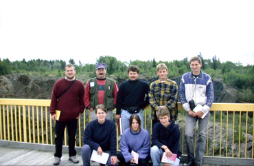
Paricipants of the field trip were: Zsolt Benkó, Emese Gáspár, Zsolt Hefner, Tamás Mikes, Tamás Pocsai, Szilvia Simon, Krisztián Szentpéteri, Zsófia Wáczek, Zoltán Zajacz as well as Dr. Feri Molnár. The field trip, the first one in overseas for the undergraduates of the Eötvös University, was a resounding success.

We thank the Partnership for Tomorrow Programme of the Federal Government of Canada for providing generous financial support, without which the trip would not have been possible. We are indebted to Dr. Feri Molnár and Dawid H. Watkinson for his efforts in perfectly coordinating several day trips and arranging for professionals to lead us, moreover for the thankless tasks he carried out with our administrative duties.

Special thanks also go to Professor David H. Watkinson and George B. Skippen for his excellent guidance, and for his hospitality at the Carleton University. His familiarity with, and understanding of Sudbury geology and geochemistry made it possible to see and learn much in such a short period of time.