| Tokaj Mountains Field Trip 2002: |
|
||
|
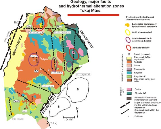
Introduction to Tokaj Mountains Geology The Tokaj Mountains are situated in northeastern Hungary and host one of the oldest Au-Ag-base metal mining districts of the Tertiary-Quaternary volcanic arc of the Carpathians. The first documentation of mining activity of the Telkibánya area in the northern Tokaj Mtns. was a 14th century order from the Hungarian Royal Court, in which the borders of the mining field coincident with the presently known distribution of mineralization were defined (Benke, 1988). During the Medieval Ages Telkibánya reached the rank of a Royal Mining Town and was a regular member of the Council of the Lower-Hungarian Mining Court. During the 20th. century the Tokaj Mtns. were intensively explored for precious metals and exploited for-raw materials such as clays (kaolinite, illite, bentonite), zeolites, pure silica and alunite, as well as perlite and andesite for building and road construction. The only pure illite deposit of Europe occurs at Füzérradvány and the perlite mine at Pálháza is among the largest in Europe. There has been no mining of precious metals during this Mtns. However, the reform of the mining laws of Hungary in 1993 brought them into with European Community standards. This move and the potential of the area triggered exploration by a number of mining companies. Tectonic setting The Tokaj Mountains comprise the central-northern part of the Carpathian Volcanic Chain, an arc that is genetically related to subduction of an oceanic slab between the European and African plates. Subduction occurred from the north-northeast in the Western Carpathians and from the east in the Eastern Carpathians during the Upper Tertiary-Quaternary (Radulescu and Sandulescu, 1973; Royden, 1988; Csontos et al., 1992; Lexa, 1999). The Tokaj Mnts. comprise the southern part of the Slanské-Tokaj Unit, a volcanic range situated in a 1.5 to 3 km deep graben ca. 100 km long and 15 to 20 km wide in northeastern Hungary and eastern Slovakia. The graben is filled by a Middle-Upper Miocene (Badenian-Sarmatian-pamionian) volcanic-sedimentary sequence and is bordered by the north-northeast trending Hernád Fault and the northwest trending Szamos Fault (Pantó 1968, Gyarmati 1977).
The southeast margin of the graben is bordered by the northeast-trending Bodrog Fault, which is a part of the major strike-slip, left-lateral Zagreb-Zemplen Fault of the Pannonian Basin. Within the graben the major faults trend north-south or nearly perpendicular to the Bodrog Fault. Paleomagnetic data indicate that during the Miocene an approximately 30° counterclockwise rotation occurred in some regions of the Tokaj Mtns. (Balla, 1987; Csontos et al., 1991). The strike-slip movement along the Zagreb-Zemplén Fault caused about 300 km northeastward displacement of crustal units, culminating in the Early Miocene. The s-1 direction of the regional stress field in the Pannonian area changed from north to the east after the Badenian (Csontos et al., 1991; Csontos etal., 1992) This change in the stress field was caused by the migration of the Carpathian subduction front from west east. This migration was also accompanied by the change of subduction from oblique in the west to perpendicular in the east. During this tectonic evolution local pull-apart features developed along the regional strike slip faults (Horváth, 1993). The opening of the north-south oriented graben of the graben of the Tokaj Mtns. appears related to pull-apart extension generated by the large-scale strike slip faulting. Thus the pattern of faults within the graben reflect the change of the regional stress field from north-south to east-west directions. The basement within the eastern part of the graben consists of Precambrian gneiss and mica schist, related to an Assyntian metamorphism (962 Ma), Paleozoic porphyroids (metamorphosed during the Caledonian orogenesis at about 450 Ma), sandstone, conglomerate and shale (metamorphosed during the Saalian Orogeny), and Triassic to Jurassic limestone and dolomite. Along the eastern border of the graben these rocks are exposed north of the Szamos Fault west of the fault these rocks occur at 960 m depth. According to regional geophysical surveys (Zentai 1991), the basement along the western part of the depression is at least at 1500-2000 m depth.
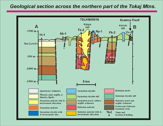
Volcanic startigraphy Badenian Volcanism started in the Middle Miocene (Badenian) with an eruptive phase that resulted in the accunimulation of thick rhyodacitic tuff (ignimbrite, ash flow and pumice deposits) at 15.2±1.3 and 13.0 ± 0.6 Ma (Pecskay et al., 1986). The eruptive centers of the Bademan tuff are related to the northwest trending Szainos Fault. The early eruptive phase was followed by graben subsidence and marine transgression from the northeast. The occurrence of various species of Bulimina and Bolivina foranuniferas in the marine clay and marl beds confirms the upper Badenian age of these sediments (Bóczán et al., 1966). The andesitic and dacitic volcamcs succeeding this stage were mostly emplaced in a submarine environment, resulting in various types of peperitic and brecciated rocks intercalated with shallow marine clays, mails and fine sands. Small and shallow subvolcanic andesitic-dacitic intrusions were also associated with the Badenian volcanic activity and these intrusions now crop out in the northeastern part of the Tokaj Mts. or are known from the deepest parts of the Telkibánya (Th)-2, Füzérkajata (Fk)-2 and Tállya (Ta)- 15 drillings. At the end of the Badenian, volcanic activity temporarily ceased. At about the same tine, differential uplift of the basement started resulting in the regression of the Bademan sea. Deposition of shallow marine-brackish water clay, marl, sand and reworked volcanic material was restricted to small basins and embayments in some parts of the Tokaj Mtns. The presence of endemic foraminifera and mollusca species indicates a strongly differentiated landscape with disconnected lagoons and bays (Bóczán et al., 1966).
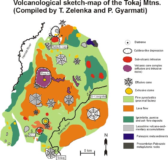
Sarmatian-Pannonian The Sarmatian-Pannonian volcanic phase consisted of successive deposition of acidic and intermediate rocks and basaltic volcanism in the final stage. According to Mátyás (1974), the general evolution of the Sarmatian. Pannonian volcanism in different parts of the Tokaj Mts. was initiated by eruptions resulting in rhyolitic tuff up to 600 m thick, accumulating under partly subaqueous, partly subaerial conditions. In the volcanic centers these tuffs are associated with small rhyolite extrusions. The products of this volcanic stage crop out in the northern part of Tokaj Mtns., as well as in the east and south Tokaj Mtns. in an area around Sárospatak, Erdõbénye, Mád and Szerencs (Fig. 1). Eruption and deposition of andesitic-dacitic lavas and their tuffs followed. Centers of this volcanic stage form caldera-like depressions and circular structures in the vicinity of Telkibánya, Regéc and Mád, as well as cones in the central parts of the Tokaj Mts (Fig.3). The subvolcanic-intrusive bodies of the lower andesite are located in the caldera-like structures and are characterised by propylitic and adularia-sericite alteration (Telkibánya, Mád, Regéc, Fig. 3). The caldera-like depressions are also associated with andesitic cones (Telkibánya, Regéc) or extrusions of rhyolite and dacite (all centers). The K/Ar ages of rocks from these centers cluster between 12.5 and 11.5 Ma (Pécskay et al., 1986). During the major stages of the Sarmatian andesitic volcanism some areas of the Tokaj Mts. were still covered by a shallow sea. Therefore, tuffaceous accumulations are often well bedded and intercalated with elastic- pelitic sedimentary rocks deposited in brackish water. Synchronously with or succeeding the accumulation of the lower andesite units, rhyolitic volcanic centers formed independently in three major areas between Telkibánya and Sárospatak, as well as in the vicinity of Erdõbénye and Mád (Fig. 1). Around the rhyolite domes of these centers various distal and proximal facies of volcanic formations can be traced, including gas-rich, fluidal, spherulitic and perlitic lava flows as well as debris flows. The most typical K/Ar ages of these rocks are between 11 and 12 Ma (Pécskay et al., 1986). The late stage of volcanic activity was characterised by either pyroxene andesite lavas or local dacite rhyolite products. Dacitic extrusions and intrusions occur sporadically in the area of the Tokaj Mtns; the most important occurrence is at Tokaj (Figs. 1 and Fig. 3). K/Ar ages of rocks deposited during the late, Pannonian stages of volcanic activity are mostly between 10 and 11 Ma (Pécskay et al., 1986). The olivine basalt of the final stage of the volcanic activity (9.4 ± 0.5 Ma; Pécskay et al., 1986) is not exposed in the Tokaj Mtns.; it is covered by Pannonian and younger sediments and is known only from drilling in the vicinity of Sárospatak along the eastern boundary of the Tokaj Mtns. (Figs. 1 and 3). Goechemistry The Sarmatian-Pannonian volcanic cycle shows a more differentiated character compared with the Badenian stage (Gyarmati, 1977). Both volcanic cycles started with acidic products and evolved to an intermediate basic composition. However, the full rhyolite-rhyodacite-dacite-acidic pyroxene/amphibole andesite-pyroxene developed only during the Sarmatian-Pannonian cycle. According to Gyarmati (1977), Póka (1988) and Szabó et al (1992), the petrochemical characteristics of these volcanic rocks have a strong calc-alkaline signature with transitional character between island-arc and active continental-margin magmatic series. However, the rocks show much diversity, with high-K character (K20>2.5 Wt%) for rhyolite and some dacite and medium K character 0.75-2.5 w% K2O) for andesite and dacite. Mátyás (1974) suggested that the temporal in the composition of volcanic rocks originated from different levels of secondary magma chambers. Szabó et al. (1992) concluded that the bimodal character of volcanism indicates the existence of different magma chambers for different rock types, or a different degree of contamination in the same magma chamber. The initial 87Sr/86Sr (0.7060-0.7135), 34Nd/Nd (0.51221-0.51255) and Pb-isotopic ratios presented by Salters et al. (1988) and Downes et al. (1995) indicate a strongly contaminated character of the volcanic rocks in the Tokaj Mts. The isotopic characteristics most probably resulted from the contamination of metasedimentary or acid meta-igneous upper crust in a mantle-derived melt which composition was already modified by the subducted slab.
Typical examples of shallow low-sulfidation type epithermal mineralization Both Badenian and Sarmatian-Pannonian volcanic cycles of the Tokaj Mtns. were characterised by intense hydrothermal activity. In general, both volcanic cycles generated low-sulfidation type epithermal deposits with associated alteration. Because of the different depths of erosion, different levels of epithennal environments are exposed. There is scant evidence of volcanic-hosted massive sulfide deposits along the southwestern part of the Tokaj Mtns. (Pentelényi, 1967), and there is no evidence of porphyry-copper mineralization reported. The location of the most strongly mineralized zones is controlled by the major faults and caldera-like structures; most commonly their orientation is elongated in a north-south direction. The alteration zones at Telkibánya, Regéc, Komlóska, north of Sárospatak and around Mád appear as strong airborne potassium anomalies. Chemical analyses of altered rocks from these areas contain above 5-8 wt% K2O (Széky-Fux, 1970; Gyarmati, 1977). However, the high-K character of rhyolite may also account for the potassium anomalies around Erdõbénye and Mád. These latter areas also have positive Th-anomalies so they can be distinguished from altered areas charactersied by low Th-values. The hydrothermal zones with quartz veins surrounded by adularia-sericite alteration were the sites of the medieval gold and silver mining at Telkibánya and north of Sárospatak (Fig. 1). In similar zones at Komlóska and around Regéc, exploratory pits associated with the old mining activity can be found. In the last 100 years the alunite-kaolinite alteration zones in the Mád area and north of Sárospatak, as well as the strongly argillized (bentonitic) host rock to veins at Komlóska, have been the primary targets of clay exploration and exploitation. The small basins, formed at the late stages of volcanism in several parts of the Tokaj Mtns., host redeposited illite -(Fûzérradvány) as well as diatomite, bentonite, kaolinite and silica accumulations (Erdõbénye, Mád) as a result of combined hydrothermal and sedimentary processes. Regional geochemical surveys, based on sampling of stream sediment, soil, rock fragments and heavy mineral concentrates (Hartikainen et al., 1992), revealed that the most pronounced geochemical anomalies of Au, Ag, As, Sb, Hg are present at Telkibánya (the medieval precious-metal deposit), Füzérradvány, north of Sárospatak and around Mád. Gold is mostly associated with Ag and As anomalies at Telkibánya and north of Sárospatak, where adularia-sericite -alteration crops out. Gold anomalies are mostly associated with As, Sb and Hg anomalies northeast of Mád and at Füzéradvány, and to a less extent at Regéc, Komlóska and north of Szerencs. Silver anomalies are uncommon in areas where alunite-kaolinite steam-heated alteration as well as intensive silicification predominate. These lacustrine basins with silica deposits west of Mád, as well as at Erdõbénye and east of Regéc are characterized mostly by Sb, and show subordinate Hg and As anomalies. |
|||